
4 Days in Jerte Valley, Spain: Epic Hikes & Cherry Blossoms
- Jul 2, 2025
- 10 min read
Updated: Mar 20
Exploring Extremadura's Jerte Valley: Hikes, Towns & Villages
March 2025 [All the posts about Spain]
Autonomous communities: Extremadura, Castile and León
Accommodation: The village of Hustias
Difficulty: Easy to moderate
Duration: 4 days
Season: March–April (end of winter)

Contents
Tips for a Jerte Valley Journey

General Orientation Map of Jerte Valley
Jerte Valley, Spain - introduction
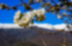
I knew we were arriving at the beginning of spring to Jerte Valley, Spain, located within the autonomous community of Extremadura. What caught my attention while preparing to come here was the cherry blossom in the valley (Valle del Jerte). It wasn’t possible to predict exactly when the peak bloom would happen, but I hoped we’d arrive on time... In the end, we missed it just a little—more on that later.

We planned a varied 4-day trip, combining scenic hikes in the beautiful surroundings of the Jerte Valley with visits to charming towns and villages nearby.
It wasn’t easy to find an isolated house in the valley area (isolated houses give me peace), so in the end, I found a house located a bit north, on the plateau above the valley, in the village of Hustias (Castile and León). But what an amazing house.
The weather here in Hustias, at about 1100 meters elevation, is cool and completely different from the valley’s weather, which is warmer.

Another place that caught my eye is Hell Canyon in the Garganta de los Infiernos park. The photos I saw of the area are engraved in my memory.
The valley and its surroundings fall under the jurisdiction of the autonomous community of Extremadura in western Spain, about a two-and-a-half-hour drive from Madrid.
The fact that the area isn’t crowded with tourists—especially not in this season—was a big factor in our decision to come here. Most visitors are Spanish (We’re definitely off the tourist trail).

More trips in Spain
More Treks Around the World
Trip to Crete, Greece
Tips
We rented a house in the tiny village of Hustias, just north of Jerte Valley.
The house is wonderful, can accommodate four people, and has everything you need. Here’s a link from Airbnb– just so you get an idea, the population in the village is about twenty people.

We came specifically to the area to see the famous cherry blossom. The locals claim there are about one and a half million cherry trees here, which is said to give the region the appearance of Japan’s famous sakura.
Here, unlike in Japan, these are fruit-bearing cherry trees. In season (June–July), there are plenty of fresh cherries, and during the rest of the year, mostly jams :)

From here, we set out on day trips (in the end, we did two and a half hikes overall).
In Hustias and the nearby villages, you won’t find groceries. The best place to shop is the town of El Barco de Ávila, which is a 7-minute drive away.
Note — shops are closed between 14:00 and 17:30 (siesta time) and, of course, closed on Sundays.

You can stay in any of the villages nearby. For those planning to spend most of their time in the valley, it’s recommended to stay near the town of Jerte (if you find a good place). Just a heads-up—make sure to stock up on groceries beforehand if you’re renting a house.

Note — dining options in restaurants are relatively limited, not to mention for vegetarians or vegans.
In the town of Jerte, you’ll find a tourist information office about the valley in general, including trails and attractions in the area.
Here is a website in Spanish (which can be translated) about tourism in the valley, offering hiking routes and more information about the area.

Hustias (Ours) village and the town of El Barco de Ávila

As I mentioned, the village is really small. There’s a river flowing here, with bridges and beautiful nature right at your doorstep. The Aravalle River is very close to the village, and there’s also a nice circular trail (PR-AV 51 Ruta del Alto Aravalle). You can see the trail on the website here (for anyone who wants to start a hike right from their doorstep).


A short trip to the town of El Barco de Ávila
So, what did we find in the town? A medieval castle, a Roman bridge, and a town that’s slowly falling apart and shrinking like many villages and towns in the Spanish countryside.
Oh, and the Tormes River, now flowing strongly after the snowmelt—mainly from the Sierra de Gredos—and heavy rains that fell here not long ago.
Right now, it’s stork nesting season, and they find the castle to be quite a good spot for their nests :)

The 12th-century castle called Castillo de Valdecorneja (note—unusual opening hours) was built to protect the autonomous community of Castile and León. It’s recommended to climb its walls and enjoy the surrounding views.

Let’s be blunt—it's not easy to find a place here to get a decent cup of coffee or a proper meal. The town is also known for its high-quality white beans (used in bean stews).
In short: rent an apartment, try to catch a supermarket while it’s open (good luck!), and cook for yourselves. It might sound challenging, but it’s worth every minute.

As in many villages in the area, you mostly see elderly people with walkers or canes, sitting quietly in the late afternoon, gazing at one another and watching the day go by.

Of course, what I write here doesn’t take away from the beauty of the area or the historical charm of the town. On the contrary — the lack of tourist crowds and the almost total absence of commercialization actually allows you to finally experience the real Spain, the one without the gimmicks and tourist traps. Enjoy the ride :)


Nature Hikes
Hell’s Canyon (Garganta de los Infiernos Hike)
Walnut Canyon (Garganta de las Nogaleas Hike)
The Blossom Trail (Ruta Cerezo en Flor Hike)
First Hike: The Nature Reserve Hell’s Canyon (Reserva Natural Garganta de los Infiernos)
Difficulty: Moderate || Type: Circular
Best time to hike: Spring/Fall
Ascent: 500 m
Maximum elevation: 750 m
Length: approx. 13 km || Duration: 4 hours
Signage: Marked posts with colors (mostly yellow and white)

The reserve is beautiful and is one of the valley’s main attractions (well, maybe except for the cherry blossom).
The entrance to the reserve is here, and there's a small visitor center where you can get a map (keep in mind that the trail markings along the way can be a bit confusing).

Try not to come on weekends... or try to arrive early, as the reserve is quite popular. We hiked on a Saturday; there were quite a few hikers, but it didn’t really bother us.
There is parking at the reserve entrance — make sure to park only where permitted (sometimes there’s a fee of about 4 euros per day).

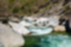
There are several hiking options in the reserve. The shortest is to reach the impressive canyon (Garganta de los Infiernos), which literally translates to “Hells Canyon,” and return the same way (6 km round trip total).

We chose to take a longer circular route that includes encounters with waterfalls, bridges, and views of the snow on the peaks of Sierra de Béjar and the peaks of Sierra de Gredos.
I’m attaching the trail map page for you, and later also the navigation file in GPX format.

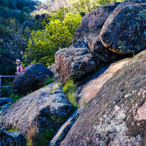
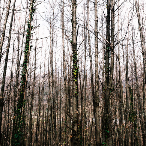
At the start of the hike, there’s an uphill climb that’s not easy but not too difficult, through a beautiful forest of trees.
The scenery changes with the seasons. Now, at the end of winter and beginning of spring, the trees are bare and starting to bud, and flowers are popping up along the way. The water flow is incredible.
After about 3 km, when you reach the canyon—be careful not to enter the water, as the current is very strong. You can dip your feet and refresh yourself. The view of the canyon is impressive, and the water flow is powerful.
In summer, the flow is weaker, allowing for a better look at the uniquely shaped rock pools (los pilones), and you can also swim.


Spanish hikers are very polite and give way to faster walkers, even apologizing for it. There are quite a few hikers here, and the atmosphere is wonderful.

After exiting the canyon, continue along the trail with a gentle uphill climb, walking parallel above the river.

When we reached this bridge, we took a break in the shade beneath it, right next to the rushing river.

After that, continue back toward the town of Jerte, first through a forest on flat terrain, then with some steep downhill sections.
From the town, return to the start of the trail along the Jerte River. On the descent, we encountered many cherry trees beginning to bloom, as well as some in full bloom.
This trail partially overlaps with the long Blossom Trail that winds through the cherry terraces in this area.


Navigation file attached
Second Hike – Walnut Canyon (Ruta Garganta de las Nogaleas)
Difficulty: Easy+ || Type: Circular
Best time to hike: Spring/Fall
Ascent: 315 m || Maximum elevation: 786 m
Length: approx. 5.2 km || Duration: 2 hours
Signage: Marked posts with green and white colors (SL-CC 33)

We decided to switch things up and headed out in the afternoon for this short hike, which is one of the most popular in the valley. There’s light outside until 9PM now, so why not?
The trail starts right here, inside the village of Navaconcejo. Look for the route that climbs alongside the stream and marked in green and white.

The trail climbs along the stream, accompanied by impressive, powerful waterfalls.
The ascent isn’t easy—about 2 km up to the higher part of the route. I guess we arrived at a perfect time—winter is coming to an end and the crazy amount of rain that fell in the area, adds to the strong water flow here.

At first, the trail looked like a nice little path with some waterfalls, forest, and greenery, but as we climbed higher, we discovered the power of waterfalls like I haven’t seen in a long time.

Wait for the last waterfall, which can be seen from the iron bridge at its base—it’s simply stunning and powerful.

The return route follows a wide path winding through the cherry terraces (which bloom in early April), about 3 km downhill all the way to the village at the valley’s base.


I’m attaching the trail on the valley’s website (in Spanish, but it can be translated).
When we got back down to the village of Navaconcejo, we wanted to eat something, but there’s not much here besides beer and potato chips. Oh, and a small plate of olives :)
Navigation file attached
Hike on Part of the Cherry Blossom Trail (Ruta Cerezo en Flor)
Difficulty: Easy || Type: Linear
Best time to hike: Spring/Fall
Ascent: 186m || Maximum elevation: 720m
Length: approx. 5.2 km || Duration: 2 hours
Signage: Marked posts with yellow and white colors and a unique trail symbol (PR-CC 2)
Full trail length: 22 km with about 700 m ascent

We waited as long as we could in the area to catch as much blossom as possible. I followed the relevant website every day. The weather worked a bit against us, and there was about a one-week delay in full bloom.
Below is the full blossom trail (Ruta Cerezo en Flor, PR-CC 2)

We didn’t have enough time for the full long trail, especially since we had already done part of it on the Hell’s Canyon hike (which I described earlier—the trails overlap partially)
We started walking from the village of Jerte, just after crossing the bridge, and walked about 2.5 km each way on the original trail.

Some of the trees are already blooming beautifully and abundantly now, while others are still bare. If we had a few more days, we would have experienced full bloom :)

If you want to experience the full bloom, you need to be flexible with your arrival dates here.
I’m attaching the full hike details.


Trip to the village of Piornal

A charming village in Jerte Valley (but this time above the valley). There’s art here in the form of paintings on the houses (quite common and popular in the area), sculptures, and, of course, lots of cherries. The village is located here.

Every year on January 19–20th, a festival takes place here. The mascot of the festival is Jarramplas. This character wears colorful armor and goes through the streets beating a drum.
Below is a photo from the 2024 festival.

The villagers throw turnips at the figure. The more turnips the person inside the costume can take, the higher their status in the community. The origin is unclear—maybe a pagan ritual or perhaps an ancient Christian tradition. Basically, it’s a community bonding ceremony for fighting evil and demons, all as part of the celebrations for Saint Sebastian.

One of the dreams of children in the village is to one day become Jarramplas and earn respect.
In a small museum open in the village (highly recommended), we watched videos and saw photos of the festival, and it looked very special. (If you’re here in January, you shouldn't miss it!)

The village looks lively, and you can even see renovations and new construction (very rare in villages here that are shrinking).


