
Tamang Heritage Trek in Nepal
- Feb 16
- 22 min read
Updated: Mar 14
October 2025 [All Nepal Treks]
Area: Langtang National Park
Type: Overnight stays in Tamang villages
Difficulty: Moderate-Hard
Duration: 8 days | Distance: 78 km
Total Ascent: 6,000 m | Max Elevation: 3,315 m
Best Season: Autumn/Spring
Best For: Experienced hikers
Focus: Tamang Heritage Trek in Nepal

Trips By Country
Content
Tamang Heritage Trek - Introduction
When planning our trip to Nepal, we wanted to tackle treks in both the Langtang and Annapurna regions.
Among the popular Langtang treks, you'll find Langtang Valley Trek and Gosainkunda Frozen Lakes Trek.
Following a recommendation for a local Nepali tour operator (Friendly Trekkers),
I checked their site and discovered the Tamang Heritage Trek, which quickly caught my attention for three reasons:
Fewer crowds compared to other routes
Deep connection with local people and their way of life
Perfect acclimatization for the higher-altitude Frozen Lakes trek (peak at 4,380m)
In hindsight, we made the right choice – this trek is simply fantastic! Keep reading and you'll see why :)
Quick planning note before we dive in: Our original plan was eleven days total – five days on the Tamang Heritage Trek + six days on the Frozen Lakes Trek, connected by foot via Rimche.
For the Tamang Heritage Trek alone, plan for about five days including travel to and from Kathmandu.The trek ends in Briddim village, then back to Syapru Besi and Kathmandu.
This post also covers our first days of the Frozen Lakes Trek which weather forced us to cut short.
Nepal Treks: Tamang Heritage Route Map
On the map you’ll see eight hiking sections, each marked in a different color.
The trek starts in the village of Syapru Besi and ends in the village of Dhunche.
The first five sections make up the Tamang Heritage Trek, while the remaining three are part of the Gosainkunda Frozen Lakes Trek, which we didn’t complete due to weather conditions.

Who Are the Tamang People
The Tamang tribe in Nepal is an ancient ethnic group primarily living in the Himalayan foothills, especially around Langtang Valley and the surrounding mountain ridges.
They’re known for preserving their rich traditional culture – including their own unique language, rituals, music, and dances deeply influenced by Tibetan Buddhism.

The Tamang villagers primarily make their living from agriculture, animal husbandry, and tourism. They live in tight-knit mountain communities with traditional stone houses (many of which were destroyed in the 2015 earthquake) and colorful prayer flags that give the area its unique aesthetic charm.

Tamang heritage preserves ancient ways of life and rituals, and today it’s also showcased through cultural trekking routes like this one, where travelers can experience local daily life, prayers, and traditions up close.
Staying in authentic Tamang villages not only offers a deeper cultural experience in the Himalayas, it also provides important economic support to rural communities striving to keep their traditions alive in the modern era.

Tamang Heritage Trek Tips
Flights to Nepal
There are several ways to get to Kathmandu. You can fly from India (Delhi), Thailand (Bangkok), or Dubai—just choose your preferred airline and route.
Nepal Visa for Tourists: How to Get It on Arrival
Get your visa and pay right after landing at Kathmandu airport at the convenient counters.
We got a 30-day visa for $50. You can extend for a minimum of 15 days.
Pro tip: Have an onward ticket out of Nepal ready. They usually don’t ask to see it, but they might. No onward ticket? Get a temporary one that cancels after 48 hours here.
Missed your visa by 1-2 days? You can pay the extension right at the airport (a bit awkward but works – $45 for 15 extra days per person).
Do it the right way: Fill the online form here, go to a bank to pay, then visit immigration police (Kathmandu or Pokhara) for your stamp. (Longer process but cheaper).

When is the Best Time to Trek?
The best months to trek are mid‑March to April to mid‑May, and mid‑September to October to November. In autumn, the skies are usually clearer with excellent visibility, as long as it’s not raining or foggy, which is perfect for Himalaya trekking and mountain photography.
In spring, you’ll enjoy the colorful bloom of Rhododendron trees (Nepal’s national flower) along with many other flowers and shrubs, making it a great season for nature and landscape lovers.
Vaccinations for Nepal Treks
It’s strongly recommended to consult a travel clinic or your local health provider before your trip, to get personalized advice and vaccinations. For this trek, we received rabies, Hepatitis A, tetanus, Japanese encephalitis, and typhoid shots, which are commonly suggested for remote trekking regions in Nepal.
Travel Medical Insurance
Make sure you purchase travel insurance that covers trekking and emergency evacuation, including helicopter rescue if needed. Whatever company you choose, verify that high‑altitude trekking and medical evacuation are explicitly included in the policy.

Trek Difficulty & Who It’s For
Best for fit hikers—you need to be in good shape for this one. True, the Tamang Heritage Trek isn’t among Nepal’s hardest routes (it’s not super high-altitude by Nepali standards), but it features steep climbs over short distances that will test your fitness.
Prep tip: Start training 2-3 months ahead – stairs, hiking, running, gym work. If you’re already doing regular cardio, you’ll manage fine.
As the Nepalis say: "Bistari bistari" (slowly, slowly) – everyone gets there eventually. The trail is very clear and straightforward (no technical passes or scary sections). Plus, it’s far less crowded than popular Langtang routes, giving you that intimate, authentic Himalayan trek feeling other trails lack.

Self-Guided Trek or With Guide/Porter?
The Tamang Heritage Trek doesn’t require a guide, so you can organize everything yourself (and save money).
We chose a private guided package because we didn’t want to deal with admin work, bookings, or carrying heavy gear. We booked a custom package through a local Nepali company called Friendly Trekkers, run by Chandra (based in Pokhara, but they organize Langtang treks too).
Highly recommend Chandra and his team! His website here
You can text Chandra directly to arrange a call: +977 984-6380439 (Chandra Bahadur Bhujel).
What the package included:
Roundtrip Kathmandu transport by jeep
All required permits
Twin rooms in teahouses
Three meals daily
Guide + porter support
His prices are very competitive compared to other operators.
Extra expenses: tips for guide/porter, hot showers, Wi-Fi, device charging, and drinks/snacks beyond meals.
DIY option: You can trek independently without guide or porter – just means carrying all your gear, booking teahouses yourself, and handling permits/transport.

How to Get There & Where to Start
The trek begins in Syapru Besi village – the gateway to Langtang National Park, located 115 km from Kathmandu.
Getting there options:
Tourist bus: 7-8 hours
Private jeep: 5-6 hours (we took the jeep)
Tamang Heritage Trek Extensions
Our original plan combined the Tamang Heritage Trek with the Gosainkunda Frozen Lakes Trek, totaling 11 days (5 days Tamang + 6 days Frozen Lakes).
Mother Nature had other plans – we completed the full Tamang Heritage Trek but only managed 3 additional days on the Frozen Lakes route before harsh weather forced us to turn back.
Summary & Trek Combinations
Tamang Heritage Trek only – perfect standalone adventure
Combine with Langtang Valley Trek – continue from Briddhim toward Rimche or Lama Hotel, then follow the Langtang route
Combine with Gosainkunda Frozen Lakes – from Briddhim via Rimche → Thulo Shyapru → continue to Gosainkunda
Pro tip: Whichever combination you choose, plan your route carefully as the trail connections between Briddhim, Rimche, and Lama Hotel are key junction points for multi-trek itineraries in Langtang National Park.

Altitude Acclimatization
If you're doing just the Tamang Heritage Trek, altitude pills aren't necessary, but definitely respect the elevation. The highest point is around 3,200m.
If combining with higher treks (above 3,500m), prepare and acclimatize properly – space out your ascent. For those using pills, take half in the morning, half at night.
Laundry
You can wash clothes daily (bring textile shampoo!). The challenge is drying – weather can turn cloudy/foggy, slowing the process. Hang clothes to dry (bring clothespins). If still damp in the morning, tie to your backpack.
Photography Gear
2 memory cards (256GB+ each)
2 camera batteries
Very small/light tripod (optional but great for night shots)
Lenses: Zoom lenses as light as possible (full-frame equivalents: 24-70mm + 70-210mm)
Pro tips: Store photos on cards and dump them post-trek. All teahouses offer charging (small fee in some places) unless there's a power cut. Camera strap clip on your backpack's front strap keeps hands free for trekking poles.

Accommodation
Our teahouse stays were pre-booked by the trekking company. On the Tamang Heritage Trek, there aren't many lodging options in the villages you'll overnight – full accommodation list here.
Booking tip: If you haven't reserved everything in advance, book your next night's stay each day. Ask the owner of your current teahouse for help (you'll need a local SIM card for calls anyway).
Rooms aren't heated, so nights get pretty chilly. In October, a sleeping bag liner works fine with the provided blankets. Cold sleepers: bring your own sleeping bag anyway.
Food & Water
Teahouse food stays fairly consistent along the trek but is surprisingly varied these days. Gone are the days of just dal bhat (rice + lentils) – menus now cater to Western trekkers with diverse options.
Unlike more popular Langtang routes, the Tamang Heritage Trek shows noticeable differences in food variety between teahouses, making each meal a little adventure.
Some teahouses even serve pizza, pasta, omelets, pancakes, butter+honey toast, milky coffee/tea. Syapru Besi has a legit espresso café (easy on day 1!). Everywhere offers dal bhat (national staple), veggie rice curry, chow mein noodles. Garlic soup appears on some menus – legend says it helps with altitude acclimatization :)
The national dish momo (steamed dumplings with veggies or chicken) shines everywhere.
Water: We used a built-in filter bottle – drink safely from almost any source, no chlorine tablets needed. Buy these in Kathmandu/Pokhara trekking shops. Refill stations everywhere, so no need to carry heavy water – just top up when you see a tap.
Trail snacks: Bananas, clementines along the route. Bigger villages have cola, beer, chips.
Protein boost: Bring protein bars from home.
Thermos hack : Small thermos filled daily with hot water for tea/coffee keeps you cozy.

Trek Navigation Guide
With a guide: Trust them completely – they know these trails like the back of their hand.
Solo trekking: Download the GPX track files attached to each trek day for precise navigation. The trail isn't formally marked, so files are essential.
Lost or unsure? Just ask locals how to reach your destination village – say the village name (no need for full conversation, they'll point you right!).
Navigation app: Download GPX Viewer (works offline, no cell service needed) to confirm you're on track.
Pro tip: Buy the Langtang Tamang Heritage map (1:50,000 scale, ISBN 978-9937-556-03-3) at Kathmandu bookstores. Shows villages, trails, and gives excellent orientation for the entire region.

Money & Trekking Costs
Bring enough cash for the entire trek. While some places accept credit cards or phone payments, many spots take cash only. No ATMs along the route (though espresso machines do exist!).
Costs overview: A guided package trek costs more but saves you booking hassle, gear carrying, and all logistics headaches.
DIY daily estimate (double room + meals): 3,000 NPR. Add extras like device charging, Wi-Fi, hot showers, beer (pricey!), coffee/tea → 4,000 NPR/day (~$28 USD, 2025 rates).
Required permits (~$40 total, 2025):
TIMS (general): Pay at Kathmandu/Pokhara tourism offices or travel agencies
LNPEP (Langtang): Pay at Langtang reserve entry or tourism offices

Communication, Power & Internet
Communication and Internet
In Kathmandu we bought a local Nepal Telecom SIM (30 GB package for 28 days) for 1,000 NPR (2025). You can buy the SIM and package at any shop selling the service.
The shops charge not-low commissions. If you need calling option too, the package gets more expensive.
Wide sections of the trek have cellular reception (network dependent). Every guesthouse had Wi-Fi, usually for 200 NPR, so you won't be cut off (except during power outages).
You can also buy an Ncell SIM if you "must have" wider coverage. Overall, Nepal Telecom provides better coverage in popular trekking areas.Check if you need calling too (e.g., booking lodgings yourself or other needs) and choose the most suitable package.
If you feel the need for a satellite phone (e.g., trekking solo), please search for such a service in Thamel gear shops in Kathmandu or even in your country.
Personally, I don't think you need one on this trek since most of the route has cell signal or guesthouse Wi-Fi. Still, if the device makes you feel safer, take one.

Electricity
Power sockets in Nepal accept both two- and three‑pin plugs check if you need an adapter. However, in many places the sockets are quite loose. A useful hack is to bring some tape and stick the plug to the misbehaving socket when needed.
It is also recommended to bring a small power strip with 2 or 3 outlets so you can charge several devices at the same time from a single wall socket. In all guesthouses you will be able to charge devices such as cameras, phones and watches. If there is no socket in the room (which is the case in most places), you can usually charge in the kitchen or dining area for a fee of 200–300 rupees.
Bring a strong enough power bank as well, in case you run into long power cuts.
Guides and Porters
There is no obligation to hire a guide for this trek, and of course no obligation to hire a porter. If you do hire a porter, make sure that their backpack can hold your gear and that the total weight does not exceed what you agreed with them or with the trekking agency (usually up to 16 kg for a couple).
Some companies provide a porter‑guide (one person doing both roles), while others split the roles between two people. On our trek we had both a guide and a porter.
Every morning you pack the porter’s bag and keep with you in your daypack only clothing layers, water and a few snacks or fruits.
Estimated cost (2025):
For a porter: 22 USD per day.
For a guide: 25 USD per day.

Accommodation List
Kathmandu - Thrive
Night 1: Syapru Besi - Hotel Peaceful
Night 2: Gatlang - Zeppa
Night 3: Tatopani - Tibet Guest House
Night 4: Thuman - Village View
Night 5: Briddhim - Norling
Night 6: Rimche - Ganesh View Hotel
Night 7: Tolos Syabru - Hotel Evening View
Night 8: Chandanbari - Deurali Hotel
Other Trips & Treks
Our trip to Andalusia Spain
Quick Jump to Trek Days
Days 1-6: Tamang Heritage Trek
Day 1 (Kathmandu - Syapru Besi)
Day 2 (Syapru Besi - Gatlang)
Day 3 (Gatlang - TatoPani)
Day 4 (TatoPani - Thuman)
Day 5 (Thuman - Briddhim)
Day 6 (Briddhim-Rimche)
Days 7-9: Part of the Frozen Lakes Trek
Day 7 (Rimche -Thulo Syabru)
Day 8 (Thulo Syabru - Chandanbari)
Day 9 (Chandanbari - Dunche)
Day 1 (Katmandu - Syapru Besi)

Today we hopped into a jeep and drove 6 hours (with coffee breaks in the morning and lunch in Dhunche – the same place we'd end our trek. At 14:00 we arrived at Syapru Besi and checked into Hotel Peaceful. Our room was on the 3rd floor, no elevator :)
Leaving Kathmandu, the suburban sights are pretty rough. The river is heavily polluted and people genuinely live on the streets. It feels like not much has changed here in decades.
The drive to the trailhead is not easy at all. Long stretches are on very bumpy dirt roads. We traveled in a jeep with our guide Yuba, the driver, and 2 additional guides who joined for the ride. There are checkpoints along the way, and approaching Dhunche we enter Langtang National Park.

The village of Syapru Besi is a really calm, pleasant place on the banks of the Trishuli River. There’s nothing here that’s especially dramatic, but a brand‑new café called
La Strada Café, which opened just two weeks ago, is beautifully designed and serves genuinely good coffee. There are also a few simple local restaurants and a couple of small shops.

The Diwali festival (Diwali) has been celebrated here over the last few days (it lasts five days) and it is a holiday/festival where everything is lit up with lights, candles, and also fireworks.
The main idea is driving away the darkness and welcoming light and joy. The village kids, a bit like on Halloween, go from house to house, sing, and receive a little money and blessings with a sprinkle of rice – it’s absolutely delightful.
Day 2 (Syapru Besi - Gatlang)
Difficulty: Medium-Hard
Elevation Gain: 1,000 m
Elevation Loss: 123 m | Distance: 11.5 km
Min Elevation: 1,500 m | Max Elevation: 2,360 m
Total Walking Time: 4:30 | Net Walking Time: 3:30

This is day one of the actual trekking, and the excitement is at its peak. We get up at 6:30, organize with the porter's bag and our own packs. I head out to grab coffee from the café across from the hotel. Breakfast is oatmeal porridge, toast with fried eggs and tea, then we're off on the trail.

The first three kilometers are a tough uphill climb with nearly 800 meters of elevation gain. We took a shortcut trail instead of the vehicle road, making the ascent harder but significantly shorter.

We pass through a pine forest and catch sight of beautiful white peaks to the north and east. We reach the top of the climb where there are a few buildings – we stop for tea. Dorit makes paper boats for the landowner's grandson, and he sails them in a bucket of water. There's a nice breeze so I take off my sweat-soaked shirt and dry it on the fence.

From there we continue on an easy walking vehicle road all the way to Gatlang village (2,360 m). The path passes through coniferous forests with beautiful vegetation.

Occasionally we catch glimpses of the snow-capped peaks. We take only short breaks and continue until the village comes into view in the distance.
Some village houses have blue metal roofs replaced after the 2015 earthquake. We arrive at our guesthouse called Zeppa. The room is very basic but we have Wi-Fi and power sockets in the room. What a luxury!
We take a bucket shower (hot water bucket + trickle shower)... Lunch – we're starving... Fried rice with egg, vegetable rice, soup, and also chapati.

I head out for some photography and catch a guy weaving reed baskets and cute girls who know a bit of English. They study at a boarding school in Kathmandu and come to visit during holidays. Not a few kids from these remote areas study in big cities like Kathmandu. I assume only families who can afford it do this.

The locals here grow potatoes and cabbage and also herd sheep and goats. Some are starting to get into the tourism business. This trek is less popular, so tourist income is accordingly lower. It's important to travel here too to encourage the local population.

Day 2: Elevation Profile Map

Navigation file (GPX format)
Difficulty: Medium-Hard | Elevation Gain: 900 m
Elevation Loss: 636 m | Distance: 11.4 km
Min Elevation: 1,770 m | Max Elevation: 2,600 m
Total Walking Time: 4:30 | Net Walking Time: 3:40

We set out as usual around 8:00 descending through village houses and agricultural terraces. They're growing beans and pumpkins here now. The potatoes were just harvested.
Every house has an outdoor water tap used for laundry, drinking, and showers. Life here is very simple and basic, like in many of Nepal's remote areas.

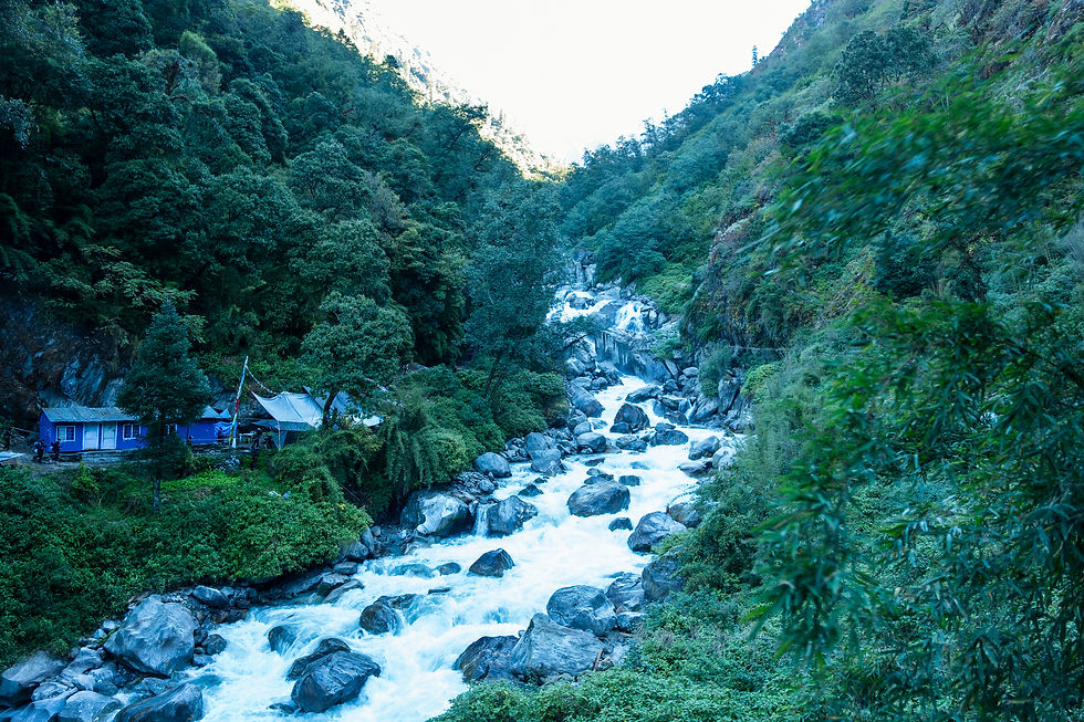
We descended all the way to the Bamdang Khola river (1,770 m) and continued alongside it to Chilime village where we took a tea break with bagels and a protein snack.

After our tea break and crossing the river, we began a steep uphill climb to 2,300 m reaching Gongang village where we had lunch with garlic soup and rice curry. Then a more moderate ascent to Tatopani ("hot water" in Nepali) at 2,600 m. After crossing the river we see a beautiful peak to our northwest.

The village has hot springs collected into several artificial pools. I took a dip and it was very special and enjoyable. Part of the hot springs complex was destroyed in the 2015 earthquake.


Today's guesthouse is Tibet Guest House (not the one pictured up here). Very basic, but there's electricity and even internet. We're sleeping in a simple room with plywood walls. Ordered dinner for 18:30 and looks like we'll turn in relatively early tonight.

Day 3: Elevation Profile Map

Navigation file (GPX format)
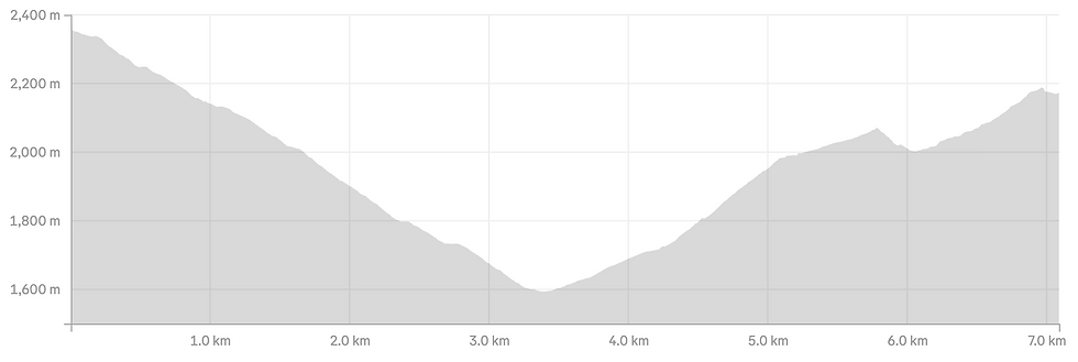
Difficulty: Medium-Hard | Ascent: 650 m
Descent: 800 m | Distance: 9.1 km
Min Elevation: 1,770 m | Max Elevation: 3,200 m
Total Walking Time: 6:00 | Net Walking Time: 3:20

The day is roughly split half and half between uphill and downhill walking, and is considered the most scenic day of the entire trek. We left Tatopani after a breakfast of pancakes and an omelet served on chapati, with tahini we’d brought from home.
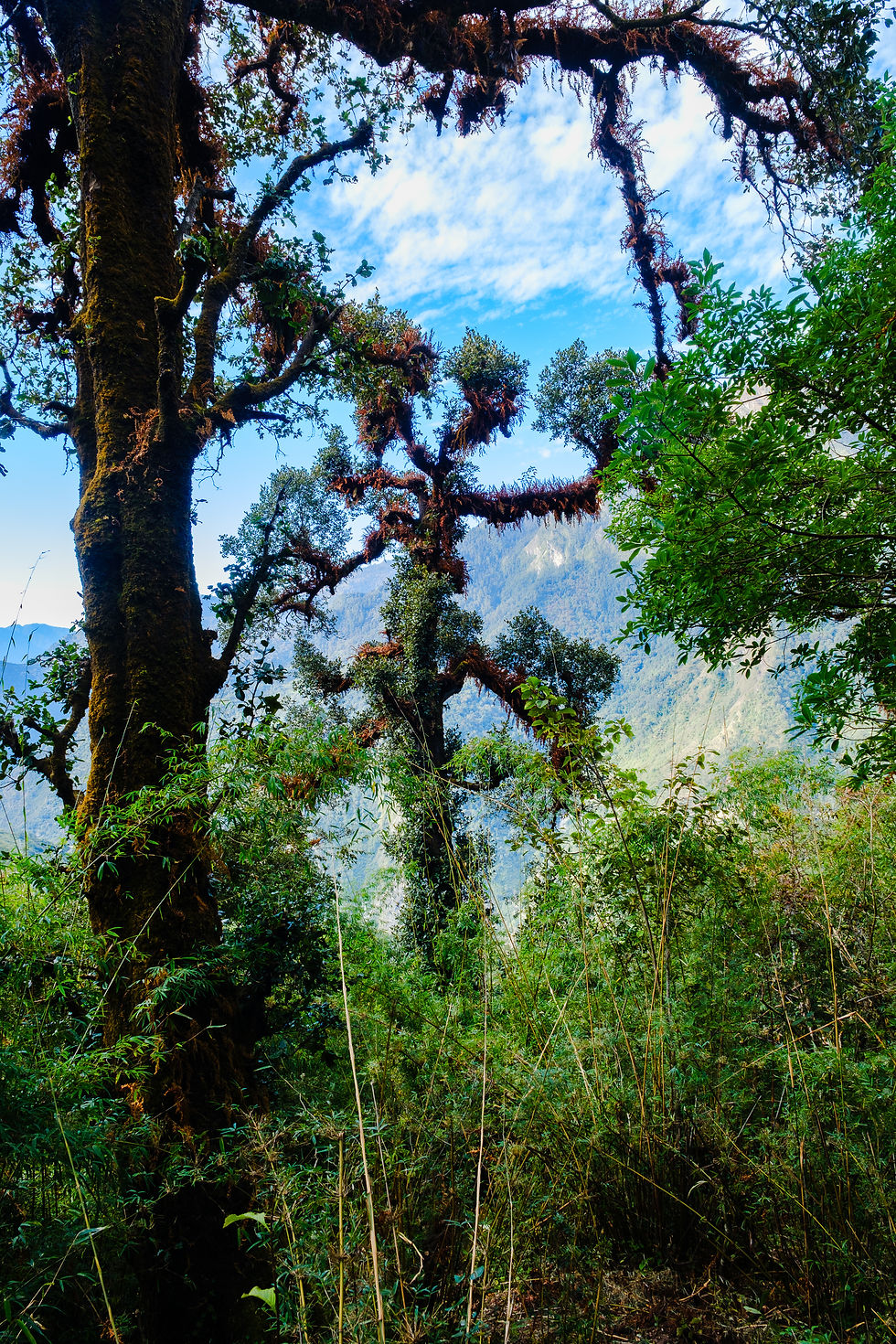
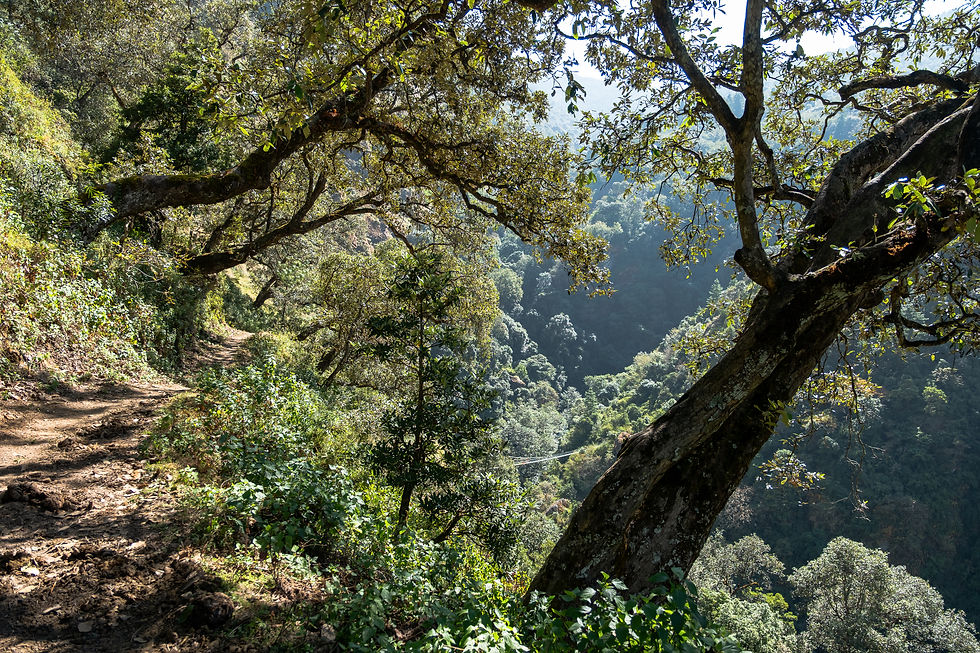
We started climbing through a beautiful forest, then continued along a trail that passed a cow pasture and herders living in a makeshift residential area, quite similar to Bedouin shepherds back home.

We continued up a steep climb until we reached a lovely temple complex adorned with prayer wheels. There, we stopped for a cup of tea and couldn’t resist buying a few colorful bracelets. The place is called Bimdang — and I even spotted a monkey sitting on one of the trees!

We continued climbing, enjoying breathtaking views of the Langtang and Ganesh Himal ranges, until we reached the village of Nagthali (3,200 m). There, we had lunch at Nagthali All Pick View Guest House and took some time to relax, soaking in the stunning panorama spread out before us. Travelers who want to linger and fully take in the scenery can spend the night at one of the local teahouses.


From there, we descended steeply 800 meters over about 4 km through a lovely forest and pasturelands until we reached the village of Thuman. Midway down, we spotted a prayer wheel with a bell powered by water flow (there are plenty of these in the villages)—a brilliant solution for endless prayer. Tonight, we're staying at Village View & Guest House.
Day 4: Elevation Profile Map

Navigation file (GPX format)
Difficulty: Medium | Ascent: 660 m
Descent: 840 m | Distance: 7 km
Min Elevation: 1,600 m | Max Elevation: 2,350 m
Total Walking Time: 4:00 | Net Walking Time: 2:30

We started the day descending through Thuman village toward the river. We passed the local temple and spun the prayer wheels.


We continued down a steep descent through meadows and low forest until we reached the river, where we crossed a bridge about 200 meters long to the other side.

We continued climbing toward Lingling village. We stopped for tea at Ling Ling Top Morning View, where we met a lovely family with a baby born just two months ago.
The mother had given birth in Kathmandu (a 12-hour bus trip). It really puts things in perspective seeing how this family gets by with a bit of tourism, a bit of farming, and their own crops. (The baby’s “big” sister appears in the featured image of the post.)

We pressed on through what trekkers in Nepal call "Nepali Flat" (a little inside joke)—a slightly more gradual climb along a wide, vehicle-friendly trail (no real flat terrain here, just ups and downs :).
The easygoing part doesn't last long though, as a tough, steep ascent soon kicks in. After the climb comes a relatively short descent to the river, where we passed an impressive waterfall in lush tropical forest, then continued upward toward Briddim village.

We stayed at a small guesthouse called Norling with three cozy rooms. After a hot shower for 300 rupees, we had lunch (fried rice with vegetables, garlic soup, noodle soup with egg, and rice with veggie curry). All the vegetables were fresh (spinach, cauliflower, cabbage, potatoes).
The family's cute kids help mom with cooking, serving the meal, and washing dishes. The father works as a porter and is currently out with trekkers in Langtang National Park.

After some rest, I hiked up to the monastery at the top of the village, which was beautiful but empty. I photographed plowing with oxen.
I didn't know it before, but there are tomato trees here... the fruits really do look like tomatoes and are mainly used for pickling. There are also walnut trees—even Ram found us some and we ate them.

Day 5: Elevation Profile Map
Navigation file (GPX format)
Difficulty: Medium-Hard | Ascent: 950 m
Descent: 600 m | Distance: 13.2 km
Min Elevation: 2,165 m | Max Elevation: 2,779 m
Total Walking Time: 5:20 | Net Walking Time: 3:30
In fact, this is the connecting day between the Tamang Heritage Trail and the Gosaikunda Lake Trek that we did—or the final day of the Tamang trek with a walk back to Syapru Besi.
Those not continuing to the Gosaikunda trek or Langtang Valley trek return directly from Briddim to Syapru Besi (just 3-4 hours of walking, mostly downhill) via Khangjim village, from where you can head back to Kathmandu the same day by jeep or bus (5-7 hours drive).
We started with a climb from Briddim village through beautiful forest. We passed through Khangjim village (2,235 m), where we met a woman working at a loom.

We continued with ups and downs until Sherpagon village, where we had lunch with a beautiful view from the terrace. During lunch, a large group of monkeys arrived from the valley.

From there, it was another hour to Rimche (2,455 m). Conditions here are pretty basic—a very small room with "walls" made of plywood. Lucky everyone crashes after dinner.
The place is called Ganesh View Hotel and espresso station—they even have an espresso machine, which is pretty hilarious. We showered with hot water and I had a cappuccino. It's a junction for folks heading to/from Lama Hotel and those coming/going to Thulo-Syabru. Pretty crowded here.

Today we met quite a few people along the trail—unlike the Tamang Heritage Trail where we barely saw anyone. We chatted with three educated young Nepalis, and it seems the education and economic gaps between them and many other young Nepalis are huge.

It even seemed like our guide and porter didn't particularly like them (maybe due to class differences—hard to say). We also met two sister students—one studying for a computer science degree, the other law—and it was interesting talking with them.
Day 6: Elevation Profile Map

Navigation file (GPX format)
Day 7 (Rimche -Thulo Syabru)
Difficulty: Medium | Ascent: 768 m
Descent: 600 m | Distance: 10.85 km
Min Elevation: 2,244 m | Max Elevation: 2,470 m
Total Walking Time: 5:30 | Net Walking Time: 4:00

In the morning, we started descending toward the river (lots of trekkers climbing up toward us). The descent is pretty steep. We reached the bridge and crossed it. Masses of Nepalis trek here—it felt surprising but nice to see them out hiking, even those who look totally out of shape.

We passed through a spot called Bamboo (Bamboo), featuring a cluster of restaurants, teahouses, and a market for all the local bags and knits.
We continued downstream along the Langtang River to Pairo, where we stopped for tea and devoured a slice of snack we bought before the trek.
From there, we continued to the junction where you turn onto the trail leading to Thulo Syabru, effectively the start of the Gosaikunda Lakes trek. The junction is here: Langtang Gosaikunda Junction. From this point, the route climbs up toward the village.

We crossed a long, charming bridge through a magnificent forest and climbed through the village until we were nearly out of breath, finally reaching our hotel called Hotel Evening View.
We sat for coffee and cinnamon rolls on the roof of one of the other hotels in the village, hosted by the owner in his "German bakery"—a bit funny that in Nepal, good baked goods have to be specifically German.

I got to chat with the owner of our guesthouse about politics, Nepal, Israel, and our families—it was nice speaking English with a local. Their kids live in Australia while they run the hotel and restaurant. The view from our room window is stunning, with agricultural terraces and snow-capped peaks...
Day 7: Elevation Profile Map

Navigation file (GPX format)
Day 8 (Thulo Syabru - Chandanbari)
Difficulty: Medium-Hard | Ascent: 1,100 m
Descent: 600 m | Distance: 7.0 km
Min Elevation: 2,244 m | Max Elevation: 3,315 m
Total Walking Time: 4:30 | Net Walking Time: 3:30

After a breakfast of omelet and Tibetan bread (essentially pita with yak butter, honey), and saying goodbye to our hosts at Evening View hotel, we faced a day of continuous uphill climbing from start to finish.

A day with breathtaking views and walking through a truly magical forest, with short stops at teahouses along the way. A challenging and continuous ascent with some steep sections. We're already well-conditioned, and our bodies are rising to the challenge. We've started taking altitude acclimatization pills a day and a half ago.

On the way, we stopped for tea and a snack. The scenery looks like it was taken straight from a movie set. The combination of the peaks and the forest is simply stunning.


We arrived at Chandanbari village and our guesthouse Deurali Hotel. Most villages here in tourist areas have long shifted their main occupation to tourism, with nearly every building being a guesthouse and/or restaurant. We bought local wool hats and were happy to wear them because of the cold.


In the afternoon, it started getting really cold, and we sat in the dining room chatting with a French couple who trek a lot in Nepal, swapping stories. We also talked with a girl from Belarus who shared about the difficulties in her country and how the young people want to leave.


Toward evening, the owners light a fire and the stove heats up, easing the cold a bit.
The porters from the Belarus group drink some alcohol, sing, and dance in the "dining room." Their work is tough, and they're blowing off some steam...
We know tomorrow will be rainy but still hope in our hearts that the rain will wait until we complete the mission.


Day 8: Elevation Profile Map

Navigation file (GPX format)
Day 9 (Chandanbari - Dunche - Kathmandu)
Difficulty: Medium-Hard | Ascent: 100 m
Descent: 1,300 m | Distance: 7.5 km
Min Elevation: 1,950 m | Max Elevation: 3,315 m
Total Walking Time: 4:30 | Net Walking Time: 3:30

Early in the morning, we already heard the rain dripping on the tin roofs. We realized—from other sources too—that higher up it's even snowing, and we won't be able to complete the trek to the lakes this time.

We decided to turn back since there was no point continuing in pouring rain and snow. Visibility was poor too, with fog blanketing the mountains. (It turned out we made the right call, as masses of trekkers got stuck higher up and couldn't descend.)
With heavy hearts and some disappointment, we started the long descent toward Dunche. Rain fell the entire way, and despite our rain jackets and pants, we gradually got soaked.

The descent was tough because everything turned slippery. I gave up on the trekking poles since I don't have rainproof gloves (do those even exist?).

On the way, we stopped twice for tea. We reached the river, where we saw a lovely waterfall. Then the climb up to Dunche began.

A somewhat long climb, it turns out... about 100 meters up. Dunche isn't much to write home about, to be honest. At first we thought we'd sleep here and head back to Kathmandu the next day, but we managed to get a jeep and returned to Kathmandu in a bumpy but really pleasant 4+ hour drive.

On the way back, we dropped off Ram, our porter. We arrived at our hotel around 8:30 PM—what a joy to return to a cozy hotel room after an 8-day trek! :)
Day 9: Elevation Profile Map

Navigation file (GPX format)
Cheers to future treks—may we meet on the trails!
Recommended Gear and Clothing List
Basic gear like hiking boots, backpack, and trekking poles—I recommend bringing from home. The rest can be bought in Kathmandu at original stores or cheap knockoff shops. A successful trip depends heavily on quality clothing and gear, so don't skimp. Good equipment will serve you on future trips too.
Essential Gear
Daypacks 30-40 liters + rain cover (if not using a porter, go bigger)
Trekking poles
Headlamps (optional)
Heating bags or hot water bottle for cold-sensitive folks (great under blankets or in sleeping bag)
Sleeping bag or liner to warm your bag (we got bags from the trekking company). Lodgings provide blankets, but they're not always warm enough. My tip, especially for cold-sensitive trekkers heading high: buy or rent a down bag rated to -10°C.
Power strip (outlets—if any—are single and shaky; bring duct tape to secure plugs)
Sunscreen for face and body
Sunglasses
Medications, bandages, or whatever comforts you
For women: liners (no sizes available in Nepal)
Waterproof bag (to keep passport and cash dry)
Trash bags to wrap clothes if raining, plus for laundry
Wet wipes and toilet paper (none at lodgings)
Towel—thin and quick-dry preferred
Laundry clips (hang clothes to dry everywhere)
Small face towel for sweat wiping—yes, you'll sweat plenty :)
Power bank for phone/watch/camera
Laundry liquid + shampoo + soap (small bottles)
Clothing and Footwear
High, waterproof hiking boots
Flip-flops for showers/evenings (wearable with socks)
2-3 pairs socks, at least one super warm
Liner gloves + warm gloves (water-repellent if possible)
Wool hat
Buff
Sun hat
Long thermal underwear
3-4 pairs underwear
2 pairs long trekking pants + 1 short
2 super-thin, fitted long-sleeve base layers (breathable)
2 short-sleeve breathable shirts
Thin fleece
Down jacket for cold
Rain jacket and pants or poncho
Thin tracksuit to wear over thermals for evenings/sleep (like pajamas—optional)


Comments