
5 Best Day Hikes in Sierra Nevada, Spain
- Sep 22, 2024
- 14 min read
Updated: Mar 18
How to plan 5 perfect hiking days in southern Spain
June 2024 [To all the posts in Spain]
Region: Sierra Nevada, Andalusia, Spain
Difficulty: Easy to Hard
Duration: 5 days
Season: Late Spring
Additional info: National park, blooming season, village accommodations, streams, forests
Focus: 5 Best Day Hikes in the Sierra Nevada

Trips By Country
Content
5 Best Day Hikes in the Sierra Nevada - Introduction
We left the country with some concern that it might be very hot for hiking in mid-June, but we were pleasantly surprised.
The mornings are a bit chilly, with a pleasant breeze blowing, and even the sky is slightly cloudy, as if spring is resisting the sun that burns everything up and scatters the clouds as easily as protesters by ten in the morning.
There is something different here in this vast area called the Sierra Nevada National Park. It's rugged, it's bold, it's colorful, and it doesn't try to please. Like bullfighting and flamenco dancing, it feels as though I now understand a little more about the origins of the Spanish movement, and wow... Olé!
Here we are, in makeshift gear, on a day hike to Mulhacén (the highest mountain in Spain).

Reference Map (Orange- accommodations, Green-our hikes)
Down here is the house we rented in Gojar - with the chickens in the yard…

At first, we rented an apartment in Granada and stayed there for one night. Even that night turned out to be too much—the noise of cars on the street and the residents of the building, which seemed to be made of cardboard, drove us to the village of Gojar, to a secluded house with a huge yard and a chicken coop supplying fresh eggs just for us. The village is only a 15-minute drive from Granada.
I had forgotten what fresh eggs taste like. Since I was a child living in the village, where I would go to my grandfather and get fresh eggs straight from the coop.
Read all about our trip to western Spain and the hidden gems we discovered |
There was a funny moment when we arrived at the house. We received video instructions to go to a 'nursery' (a mistranslation from Google Translate by the owner) and from there to the house. We found a woman on the street and asked how to get to the 'nursery,' but we were actually standing in front of the plant nursery and mistakenly asked her in Spanish where the kindergarten was...
Near the house, there’s a stream flowing strongly and a row of cottonwood trees, whose leaves make a familiar and beloved sound as the wind blows through them. These are the sounds of nature from my childhood, and I immediately felt at home here.
Why These 5 Routes in Sierra Nevada, Andalusia?
We spent quite a bit of time choosing the hiking days. The park is quite large and divided into several hiking areas, with the option for a longer hike between huts (part of the GR-7 trail) within the reserve. This time, we decided on day hikes with light daypacks, and all of them were circular routes (except for the hike to the highest mountain, Mulhacén).

We chose two main hiking areas: one around the city of Granada and the other around Capileira. In the end, we did three hikes in the Granada area and two in the Capileira area, although we ultimately changed our accommodation to the town of Órgiva instead of staying in Capileira.
Honestly, I didn’t realize how diverse this area is and was concerned that the hikes here would all look the same.
The good news is that each hiking day offered a different slice of nature, and the two hiking areas were really quite different, even in terms of weather (it's cooler in the Capileira area).
More Treks
New: Samaria Gorge Crete
More Trips In Spain
Sierra Nevada Hiking Tips (Andalusia, Spain)
When: We hiked in mid-June and had a wonderful sunny week, with cool mornings and evenings (14-16°C) and daytime temperatures up to 28°C.
In principle, you can hike here almost all year round (on many of the trails). The higher trails above 2000 meters will be snow-covered in winter and therefore difficult to pass.
On the trails we did (except for the highest mountain), you can hike year-round. Of course, spring is more beautiful and pleasant with the blooming season until the end of June.


Hiking Difficulty: The average length of the trails is about 14 km, usually with an average ascent of 600-700 meters. Since you don't need to carry much (other than water and some food), the trails are not very difficult. I would classify them as between easy+ and moderate+ (on a scale for people who walk a lot).
Accommodation: We stayed in two places (both recommended), where you can wash clothes and cook.
The village of Gojar in a charming isolated house - Hikes 1-3
Link to the house on Airbnb here
The town of Orgiva in a detached house at the edge of the town - Hikes 4-5
Link to the house on Airbnb here
How to get there and where to finish : We arrived in Granada from Madrid by car.
We rented the car through a website: https://www.economycarrentals.com (the cheapest from the airport - they offer a shuttle to their lot from the airport). From Granada, we arrived at the accommodation.
Car navigation: Waze worked great, as did Google Maps.
Navigation on Hikes: The trails are well-marked, and there are almost no points where you might be unsure of where to go. It is essential to follow the signs (mostly wooden posts with yellow and white stripes); the trails also have markers indicating where not to go (the x symbol). If you haven’t seen a sign after 200 meters of walking, you are likely off the trail. I downloaded GPX files for the trek days onto my phone in advance and attached them to each day of the hike (use them—no cell service is needed when using them).
I used the GPX Viewer app (free), which is sufficient to keep you on track.
Water: We used hydration pouches in our backpacks (about 2 liters per day; in summer, an extra liter per person is needed). Bring water for all hikes and don’t rely on finding water in the area.


Clothing and laundry :
Walking shoes, 2 pairs of good socks, long and short walking pants, a hat, 2 short-sleeve shirts (preferably moisture-wicking), 2-3 pairs of underwear, a lightweight hiking jacket, a fitted long-sleeve shirt, a beanie or hat, light gloves, a lightweight rain jacket (it can rain in the spring—check the weather forecast for the trek days in the different areas and prepare accordingly). Of course, hiking poles.
In the morning, when it's cool, we wore a thin fitted shirt in addition to the short-sleeve shirt. For those who are sensitive to the cold, a beanie or hat can help. Around 10 AM, you start to warm up and can switch to just hiking pants and a short-sleeve shirt.
Relevant website for hikes in Sierra Nevada Andalucia
On this website of a British couple living in Granada, you can find additional trails and details about the trails we did: https://treksierranevada.com
Quick Jump to the Hiking Days in the Sierra Nevada
Day 1 hike (Canal de la Espartera)
Day 2 hike (La Silleta)
Day 3 hike (Cerro Huenes)
Day 4 hike (Mulhacén)
Day 5 hike (Puente Palo Loop)
Hikes around Granada City
Day 1 hike - (PR-A21) Canal de la Espartera in the area of Collado Sevilla
[Difficulty: Easy-Moderate || Type: Circular || When: All year round || Ascent: 550 m || Maximum altitude: 1730 meters || Length: 14 km || Duration: 5 hours || Signage: Posts with yellow and white stripes]

How to get to the Trailhead:
Type "Collado Sevilla" into Google Maps or use this
When you arrive at the restaurant, take the road to the right (do not enter the restaurant) and continue for about a kilometer to the parking lot, where you will see a sign indicating two trails departing from there: PR-A21, which we did, and PR-A20, which we also hiked and will describe on the third day of the hikes…

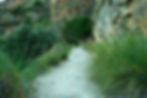
This trail can be classified as easy-moderate. Most of the trail is not forested and varies in terms of vegetation and terrain. It is surprising that even at the very end of spring, there are still stunning blooms of lovely flowers here, and even poppies are still blooming.

Initially exposed and sandy, then forested and rocky, you will eventually reach a beautiful river (Dilar) from which you ascend gradually back.

Water break halfway through the trail (Keep in mind - it is not certain that the water is safe to drink).

And here, right next to the Dilar River— a lovely spot for a rest and even for making coffee.

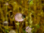
These wildflowers are simply stunning with their bright yellow color.

Example of a trail marker (all the trails we did are marked this way) with yellow and white colors and the trail code, in this case, PR-A21.

Download the trail navigation file here (note that in this file, the walk starts from the restaurant). It is possible and preferable to shorten the walk by starting from the parking lot, about a kilometer drive past the restaurant (the official start of the trail - see the sign - Collado Sevilla).
Download the trail navigation file here:
Canal de la Espartera Trail Map

Day 2 hike - (PR-A73) La Silleta in the Dilar area
[Difficulty: Moderate + || Type: Circular || When: All year round || Ascent: 730 m || Maximum altitude: 1520 meters || Length: 14 km (if starting from the village) || Duration: 4 hours || Signage: Posts with yellow and white stripes]

How to Get to the Trailhead:
Type "Dilar" or "Fuente de la Ermita" into Google Maps, which is the church at the edge of the village where you can park and walk a few hundred meters to the start of the trail itself (use the GPX file I attached).

You start this hike from the village of Dilar; we reached it by driving from the village of Gojar (it’s a short drive).
There is no need to park within the village; you can park right at the start of the trek, saving about two kilometers of walking (although walking through the village is also interesting). There is a parking lot near the church.
It’s advisable to start early in the morning, by 7 AM, both because of the heat (in summer) and to take advantage of the special morning sunlight.


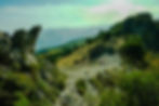
The first half of the hike is uphill. Initially, you pass through olive and almond groves along a forested path with pine trees, leading to a waypoint (trig) which is essentially a saddle (Silleta) with an amazing 360-degree view of the Sierra Nevada mountains.
Here, you can see the landscape from the highest point of the hike, and it is definitely impressive:

In the second half of the hike, you descend through a section of gravel and little stones. It’s not too complicated, but it’s advisable to use trekking poles just in case. The trail is lovely and the scenery is amazing.

When we were hiking, we saw swarms of butterflies—probably their mating season...


Download the trail navigation file here:
La Silleta Trail Map (you can skip the tail of the trail and start at the church or right next to the trail sign):

Day 3 hike - (PR-A20) Cerro Huene in the Collado Sevilla area
[Difficulty: Easy to Moderate || Type: Circular || When: All year round || Elevation gain: 550m
Maximum height: 1748m || Length: 13 km || Time: 4 hours || Marking: Posts with yellow and white stripes

How to get to the start of the trail:
Type in Google Maps: Collado Sevilla here
This hike starts from the same point as the first hike, so I won't repeat all the instructions—just go back to the first hike day and check there.
Although they start from the same point, the terrain and scenery in these two hikes are quite different, so I highly recommend doing both.
Today starts with a walk along a vehicle path (just about a kilometer), after which you begin entering a wooded area filled with rosemary and thyme plants, as if nature is hinting to us—today’s meal is Italian. How fun! I go crazy for wild herbs!

We saw two squirrels today, right after I complained that we don't see any animals on these hikes. That's how it works—only when you complain does something happen here (:
After a short climb, you can get a view of the city of Granada. Most of the trail is forested. The first half includes a moderate ascent with some steep but relatively short sections. Once you reach the highest point, an open view of the mountains appears, including remnants of snow from the winter and a descent through the forest.
Along the way, you come across a farmhouse and we even saw the goat herder with his dogs.


When you reach this beautiful bridge, continue along the path for about another kilometer with a moderate ascent to the trail's endpoint and the parking lot.

Download the trail navigation file here:
Cerro Huene Trail Map

Hikes around Capileira
After these three treks, we moved to a different area of the Sierra Nevada and booked a private house, even with a pool, in Orgiva (about an hour's drive south of Gojar).
From there, we went on two more day hikes (the house is highly recommended).
Airflow and the quiet are two essentials that make me calm and allow me to daydream. That's also when the best ideas and the most original thoughts come up, erupting and revealing themselves.
The world is becoming noisier, more intense, and violent. Here, as I lie next to the open window with the wind blowing freely, I remember those moments from childhood when I would just watch the clouds billowing through the window above my bed, and how the clouds would turn into a variety of animals, geometric shapes, or just imaginary creatures.
Before all the "smart homes" and "eco-friendly homes", my father always said – just open two windows and let the wind form and flow (and here it's part of the system). No need for air conditioning…

Day 4 Hike: Mulhacén – Spain's Highest Peak
[Difficulty: Moderate || Type: Point-to-point route || When: Summer and early autumn || Elevation gain: 900m Length: 12 km || Starting elevation: 2600 meters, Maximum elevation: 3479 meters || Time: 4 hours
Marking: None, the trail is very clear (use the attached GPX]

Registration for the trek:
You need to contact the office in Capileira to check the availability for a specific day and to reserve a spot on the shuttle.
Email address: siacsur@gmail.com - Please provide full names, desired dates, and preferred route (Mulhacén)
Or call: +34-671-564406 or +34-958-763090
You must physically go to the office and pay to secure a spot on the shuttle (14 euros per person).
Opening hours (Spring -> Fall): 09:00 - 14:00 // 16:00 - 20:00 (Monday to Saturday). Sunday: 09:00 - 14:00
You can also use the website here for additional information (a site I used for planning the routes).
How to Get to the Information Office:
Search for "Capileira" on Google Maps. The office is located right here on the main road of the village, and you can't miss it.
Actually, the highest mountain in Spain is on Tenerife in the Canary Islands: Teide (3,715 meters). However, if we are talking about the Iberian Peninsula, then Mulhacén is the highest (3,479 meters).
The journey begins with a park minibus from Capileira right here, which departs at 8:30 AM (as of June 2024).
You will travel towards the mountain for about an hour on dirt roads. Private cars are not allowed on these roads (a private vehicle can only travel part of the way until reaching a checkpoint).
The trek starts at an altitude of 2,600 meters and ascends to 3,479 meters, meaning a 900-meter climb over approximately five kilometers. The trek is linear, meaning you return on the same route and wait for the minibus that will return to the village at 4:00 PM.

The trek is stunningly beautiful and offers breathtaking views (it’s actually hard to breathe at such an altitude). On sunny days like the one we "got", you can see the Mediterranean Sea and a panoramic view of the Sierra Nevada mountains. If you go until mid-June, you can still see remnants of snow.
Keep in mind that the weather can be very cold with strong winds. In fact, we weren’t really prepared for the cold and winds, and we didn’t have gloves or wool hats, so we used socks as gloves:

In short, bring gloves, a windbreaker, and a wool hat.
In our group, there were four Spaniards and two French people, and everyone was very nice.
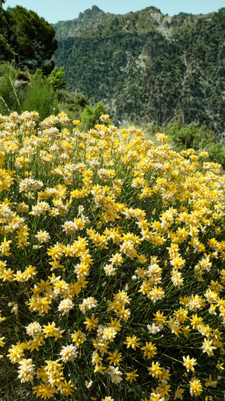
Some of the vegetation is unique to the mountain area, and up to about 3,000 meters, there are still plants; beyond that, it’s just exposed rocks. When we were there, the yellow flowers covered the ground in stunning carpets, and together with the clear blue sky, they created a magnificent picture.


You can see cute mountain goats (Ibex) here

This is the summit; it looks a bit like the mountain passes in Nepal... Cold and very impressive!

The descent is along the same route we came up and is not too complicated. We were lucky to have a special shuttle that arrived just as we finished the hike, so we went back to Capileira with it. Normally, you would need to wait for the shuttle that arrives at 4:00 PM.
Download the trail navigation file here:
Mulhacen Trail Map

Day 5 hike - Puente Palo Loop in the Capileira area
[Difficulty: Medium || Type: Loop || When: All year round || Ascent: 550 m || Maximum altitude: 1,786 meters Length: 13.5 km || Time: 4 hours || Signage: Yellow and white posts]

How to Get to the Trailhead:
On Google Maps, navigate to this point: here (https://maps.app.goo.gl/PTsEz6VNXV8qCvKb8)
We left from Órgiva and drove for about fifteen minutes on the main road, which then turns into a gravel road for another fifteen minutes or so until reaching the next sign where you can park and start the hike. The hike consists of two routes that connect.
It’s a good idea to use the navigation file to stay on the trail.

In the first section, you climb through a mixed forest of oaks and pines, which is lovely at times, with steep ascents.

In the second section, you walk along a water channel (until sometime in July, the water flows from the melting snow).
We met a charming pair of students from the University of Granada who are conducting research on birds. They have placed about a hundred artificial nests in this area and are monitoring them.

The oak trees here are simply impressive, and combined with the flowing water in the channel, the view is really cool.

We also met a group of butterfly enthusiasts from Britain who came to this area. They definitely know a thing or two about butterflies, and indeed, along the water channel and in the water pools along the way, we saw countless beautiful butterflies.


The ancient oak trees here are so impressive... It’s amazing to think about what they have “witnessed” while us humans are born while others die, wasting our very limited time on national, territorial, religious, and other trivial struggles…

When you get here (to this open section), take note: you go up a path here and then turn right on what seems like not a path, but it quickly connects to a dirt road that you continue on (follow the navigation file and everything will be fine).


Download the Puente Palo Loop trail navigation file here:
Puente Palo Loop Trail Map

Hope you enjoyed the post and want to explore this amazing Sierra Nevada area!...
Viva España!
Nimrod