
Annapurna Base Camp Trek in Nepal
- Mar 14
- 17 min read
November 2025 [All Nepal posts]
Region: Annapurna Conservation Area
Type: Village-to-village hike - linear trail
Length: ~55 km | Difficulty: Moderate-Hard
Duration: 7 days | Season: Autumn
Elevation gain: 3,900 m | Max altitude: 4,130 m
Focus: Nepal treks: Annapurna Base Camp

Trips By Country
Contents
Introduction – Annapurna Base Camp Trek
We arrived at this trek fairly experienced, after already hiking in the Langtang region — completing the Tamang Heritage Trek and part of the Frozen Lakes trail.
When planning our trekking itinerary in Nepal, we had two main regions in mind, and it felt only natural to continue to Pokhara and set out on another adventure in the Annapurna Conservation Area.

There are quite a few treks in the Annapurna Conservation Area: there’s the “Annapurna Circuit", “Mardi Himal”, “Annapurna Base Camp”, “Poon Hill” and more… so how do you choose the one that’s right for you? So, first of all, by eye: we watched YouTube videos, read a bit about the different treks, and just totally fell for what we saw on this one.

A few key factors were front and center for us: the trek's length in days, its elevation profile, and its physical difficulty. We wanted to break the 4,000-meter barrier to test ourselves and see if we could handle it.
This trek can be done in several variations. We chose the minimal option—7 days total, including travel to/from Pokhara (you can shorten it to 5-6 days if you're in a rush and okay with the altitude).
Everyone must do the core section from Samrung (the long suspension bridge) to ABC and back.
Nepal Treks: Annapurna Base Camp Trail Map
The trek is linear (out and back on the same trail), but the overnight stays—except in Dobhan—were in different places. Each hiking day is color-coded on the map (zoom in for details).
Annapurna Base Camp Trek Tips
Flights to Nepal
There are several ways to get to Kathmandu. You can fly from India (Delhi), Thailand (Bangkok), or Dubai—just choose your preferred airline and route.

Nepal Visa for Tourists: How to Get It on Arrival
Get your visa and pay right after landing at Kathmandu airport at the convenient counters.
We got a 30-day visa for $50. You can extend for a minimum of 15 days.
Pro tip: Have an onward ticket out of Nepal ready. They usually don’t ask to see it, but they might. No onward ticket? Get a temporary one that cancels after 48 hours here.
Missed your visa by 1-2 days? You can pay the extension right at the airport (a bit awkward but works – $45 for 15 extra days per person).
Do it the right way: Fill the online form here, go to a bank to pay, then visit immigration police (Kathmandu or Pokhara) for your stamp. (Longer process but cheaper).

When is the Best Time to Trek?
The best months to trek are late‑March to April to mid‑May, and late‑September to October to November. In autumn, the skies are usually clearer with excellent visibility, as long as it’s not raining or foggy, which is perfect for Himalaya trekking and mountain photography.
In spring, you’ll enjoy the colorful bloom of Rhododendron trees (Nepal’s national flower) along with many other flowers and shrubs, making it a great season for nature and landscape lovers.
Vaccinations for Nepal Treks
It’s strongly recommended to consult a travel clinic or your local health provider before your trip, to get personalized advice and vaccinations. For this trek, we received rabies, Hepatitis A, tetanus, Japanese encephalitis, and typhoid shots, which are commonly suggested for remote trekking regions in Nepal.
Travel Medical Insurance
Make sure you purchase travel insurance that covers trekking and emergency evacuation, including helicopter rescue if needed. Whatever company you choose, verify that high‑altitude trekking and medical evacuation are explicitly included in the policy.

Trek Difficulty & Who It's For
A trek for fit hikers—you need to be in good shape for this one. No shortcuts here.
Sure, you'll see very elderly people along the way, but that doesn't mean it'll be easy for you.
Prep 2-3 months ahead: stairs, walking, running, gym work. Regular aerobic exercisers will have no problem.
As Nepalis say: "Bistari bistari" (slowly, slowly)—everyone summits eventually. The trail is super clear and comfortable (no technical passes, no scary sections). It's very touristy—you'll encounter hundreds of trekkers going both ways, plus mules/donkeys on parts of the path.

Self-Guided or With Guide/Porter?
The trek doesn't require a guide, so you can organize everything yourself (it'll be cheaper).
We didn't want to deal with admin, bookings, or heavy gear, so we booked a custom package through a local Nepali company called Friendly Trekkers. Chandra runs it from Pokhara.
We highly recommend Chandra and his teams. His website here
You can text Chandra directly to arrange a call: +977 984-6380439 (Chandra Bahadur Bhujel)
Package includes: Round-trip jeep from/to Pokhara, permits, twin rooms in teahouses, three meals daily, guide + porter. His prices are very competitive.
Extra costs were on us: tips for guide/porter, hot showers, Wi-Fi, charging devices, extra food/drinks beyond meals.
As mentioned, you can go fully independent—no porter or guide. Just means carrying everything yourself, booking lodgings, handling permits + transport.

How to Get There & Where to Start
We took a tourist bus from Kathmandu to Pokhara—only 150 km but a grueling 8 hours! Book through any Kathmandu travel agency. We used Swissa agency (14$ per person 2025).
The bus ride is not easy, to say the least, due to road conditions — especially after rain. Seats are decent, but... I just remembered doing the same trip 25 years ago, and it took exactly the same time :)
Faster option: Fly Kathmandu-Pokhara (25 minutes) with Buddha Air or Yeti Airlines.
From Pokhara to trailhead (check your starting point): public bus, tourist shuttle, or jeep. We took a jeep that cut travel time significantly.

ABC Trek Variations
You can combine this trek with Poon Hill (add 3 days) or start from Nayapul or Ghorepani villages. Along the ABC route, sleep wherever suits your time, fitness, and altitude acclimatization.
Altitude Acclimatization
Trek high point: 4,130m at Annapurna Base Camp. Most trekkers need time to adjust.
We split it for proper acclimatization days. Plus, we took altitude acclimatization pills starting at 3,200m (half pill morning/evening). Don't rush—acclimatize properly.
I was worried about the altitude, but our prep worked—no issues. Walking feels harder and you're huffing, but it passes fine.

Laundry
You can wash clothes daily (bring textile shampoo). Drying is the issue—weather turns foggy/cool after noon (at least for us), so it doesn't always dry fully. Hang to dry (bring clips). If still damp, tie to your pack in the morning.
Photography Gear
2x 256GB+ memory cards
2 camera batteries
Tiny lightweight tripod (optional but great for night shots)
Lenses: zoom, as light as possible—full-frame equiv. (24-70) & (70-210)
Store all photos on cards and offload post-trek. Charge camera everywhere (small fee in some spots), unless power outage.
Tip: Strap holder on backpack's front strap keeps hands free for trekking poles.

Accommodation
Our stays were pre-booked by the trekking company. Most teahouses in a village look the same—differences come down to the cook's skills.Our lodging list here
If not pre-booked, reserve the next night's stay each day. Ask your current host for help (get a local SIM for calls).Rooms aren't heated, so nights are freezing. Bring a good sleeping bag on top of provided blankets.
Food & Water
Teahouse food is surprisingly varied (not just dal bhat anymore). Korean dishes are big due to Korean crowds. Shakshuka was once Israeli-famous but faded with fewer Israelis. Momos (steamed veggie/chicken dumplings, like Japanese gyoza) rule everywhere.
Expect pizza, pasta, omelets, pancakes, butter-honey toast, milky tea/coffee, lemon tea. Garlic soup? (Some say it helps altitude acclimatization :) Plus veggie/noodle/egg soups. Espresso machines in spots (pricey). Dal bhat, veggie curry rice, chow mein everywhere.
Water: We bought a built-in filter bottle—drink from any source, no chlorine pills. Buy in Kathmandu/Pokhara gear shops. Refill everywhere, so no need to carry much—just top up often. Fruits (bananas, clementines), snacks/drinks (cola, beer) in bigger villages.
Protein boost: Bring protein bars from home, and even some isotonic powder if you like. Small thermos for daily hot water (tea/coffee).

Trek Navigation
With a guide? Trust them—they know the way. Solo? Use attached GPX files for each day or just follow the hundreds of other tourists. Really hard to get lost here. Download an offline navigation app like GPX Viewer to confirm you're on track.
Money & Costs
Bring cash with you. Some spots take cards/phone payments, but many are cash-only. No ATMs on trail (espresso machines? Yes :)
Travel packages cost more but save hassle (lodging bookings, gear carrying, logistics). Solo daily estimate (twin room + meals): 3,000 NPR.
Daily extras - charging, Wi-Fi, hot showers, beer/coffee: ~1,000 NPR.
Total daily cost $28, 2025 rates.
One time permits (~$40 total, 2025):
TIMS (general): Pay at Kathmandu/Pokhara tourism offices or agencies
ACAP (Annapurna): Pay at conservation area entry village

Power & Communication
Getting Connected on the Trail
We grabbed a local SIM right away in Kathmandu from Nepal Telecom—went for the 30GB package good for 28 days, cost us about 1,000 NPR back in 2025. You can pick one up at pretty much any shop selling them, but heads up—they tack on a healthy markup. If you need calling minutes too (say, for booking teahouses yourself), it'll bump up the price a bit.
Cell signal? Surprisingly decent in big chunks of the trek, depending on the network. Every teahouse had Wi-Fi available—usually for around 200 NPR—so we were never totally cut off (power outages aside, of course). If you're a coverage fanatic, check out Ncell for wider reach. That said, Nepal Telecom was rock-solid in the popular trekking zones. Just figure out if calls are a must for you and snag the best-fit plan.
Feeling extra cautious? You can rent a sat phone from the. Honestly though, we didn't bother. With crowds of trekkers, guides everywhere, and cell/Wi-Fi in most spots, it felt plenty safe. But if it gives you peace of mind, go for it—no judgment!

Electricity in Nepal
Nepal uses the same plugs as europe (2 or 3 round pins), so no adapter needed! But heads up – many sockets are super loose. Pro tip: bring some Scotch tape to stick your plug firmly in place if it wobbles.
Power strip is a must – get one with 2-3 outlets so you can charge multiple devices from a single socket.
Charging options:
Some guest houses have sockets in rooms for cameras, phones, smartwatches
If no room socket (common), kitchen/dining area charging = 200-300 NPR (~$1.5)
Bring a beefy power bank – blackouts can last hours (sometimes days!)

Guides & Porters
No guide required for this trek, and porters are totally optional. If you hire a porter, make sure his bag fits your gear and stays within the agreed weight (usually max 16 kg per couple). Some companies send one guy who’s both guide+porter, others split it into two people. We had both.
Daily routine: Pack your porter bag each morning, take only daypack with clothes, water, and a few snacks/fruits.
Rough costs:
Porter: ~$22/day
Guide: ~$25/day
Accommodation list
Pokhara: Temple Bell
Night 1 - Chomrong: Excellent View Top
Night 2 - Dovan: Dovan Guest House
Night 3 - Deurali: Shangrila
Night 4 - MBC: Shankar Guest House
Night 5 - Dovan: Dovan Guest House
Night 6 - Jhinu Danda: Namaste
Other Trips & Treks
Our trip to Andalusia Spain
Quick Jump to Trek Days
Day 1 (Pokhara - Chhomrong)
Day 2 (Chhomrong - Dobhan)
Day 3 (Dobhan - Deurali)
Day 4 (Deurali - MBC)
Day 5 (MBC - ABC - Dobhan)
Day 6 (Dobhan - Jhinu danda)
Day 7 (Jhinu danda - Pokhara)
Day 1 (Pokhara - Chhomrong)
Difficulty: Medium
Elevation Gain: 600 m
Elevation Loss: 0 | Distance: 3.16 km
Min Elevation: 1,500 m | Max Elevation: 2,200 m
Net Walking Time: 1:40 | Jeep fare: 3:00

What excitement – trek day one! Short walking day but includes a bumpy jeep ride from Pokhara, so definitely a full day.
We organized at the hotel in Pokhara. Chandra handed our porter bag to sweet Bimal (just 18!), while guide Yuva we already know from previous treks "Tamang Heritage" and "Frozen Lakes."
We start on good roads that get progressively tougher as we climb into the hills.
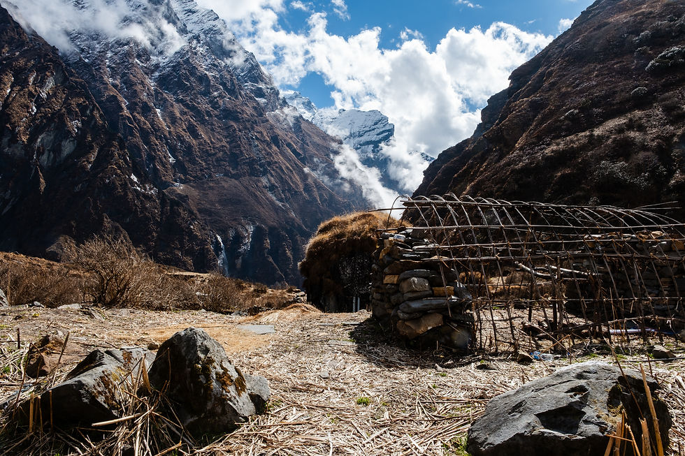
Total ~3 hours (short by Nepal standards!) and we reach Samrung – last vehicle access point and official trek start!

From here we cross the long suspension bridge (285m) over the Modi River, reaching Jinu Danda village – we'll return here at trek's end on the way back. The village has an awesome hot springs complex with fantastic natural hot water (see final day).
What makes this trek special is that from the starting point and throughout (except forest sections), you get non-stop views of snow-capped Machapuchare (Fish Tail) and Annapurna peaks. These mountains are addictive – even back in Pokhara, we kept scanning city viewpoints for them!
We continue climbing stone stairs through Taulung (2180m) up to Chhomrong at 2200m. Long, steep ascent but the stairs are relatively comfortable.

Weather turns wild – from partly cloudy and super humid to total fog with almost zero visibility.
We arrive straight to our guesthouse – Excellent View Top which, true to its ironic name, offers literally no views at all :)

Got a room shower (even almost-hot water!). Met a Scottish couple who helped pass time till dinner.
Evening getting chilly, everything's foggy. Fingers crossed for clear skies tomorrow!
Day 1 Elevation Profile (Samrung to Chhomrong)

Route Navigation File (GPX format)
Day 2 (Chhomrong - Dobhan)
Difficulty: Hard
Elevation Gain: 918 m
Elevation Loss: 680 m | Distance: 10.5 km
Min Elevation: 1,780 m | Max Elevation: 2,520 m
Total Walking Time: 6:00 | Net Walking Time: 4.00

Wow, the real Annapurna & Fish Tail views finally revealed at sunrise – absolutely stunning!
Days this season typically start with crystal-clear mornings, then clouds roll in by noon (sometimes rain), so best strategy: hit the trail early!

As usual, we eat at 7 and hit the trail before 8.
What's on the menu? Pretty standard across teahouses: pancakes + toast (yes, regular white bread) with fried eggs, served with milky tea. Plenty of fresh veggies/fruits available, so salads work too. Butter, honey, or jam round it out – solid trekker breakfast!

We head out with a steep stone stair descent to Chhomrong Khola river, cross a shorter bridge, then start a tough but manageable stair climb.
Hikers everywhere from Asia + Europe. Surprising number from India, Pakistan, Bangladesh, and local Nepalis too.
Views return – those snowy peaks shining again... We reach Shinuwa village (2350m) for tea break with epic scenery.

We continue through the forest toward the village of Bamboo (2300m), where we stop for lunch. You can also overnight here if you prefer a shorter day.
For the coffee addicts – there’s even a small café with an espresso machine.

From here we keep climbing to Dobhan village (2520m). We stay at Dovan Guest House.
No room sockets here – everything charges for a fee (no cell signal either).

Wi-Fi, device charging, and hot showers – all for a fee. Food here is delicious with homemade coffee and cakes too! ☕🍰

Device charging: 300 NPR, shower: 300 NPR, Wi-Fi: 300 NPR. Even hot water for our bottle warmers costs extra.
Nighttime chill: sleeping bags + blankets (always provided).
By 9 PM everyone's exhausted and crashes – so even with plywood "walls" between rooms, it's totally quiet.

Day 2 Elevation Profile(Chhomrong - Dobhan)

Route Navigation File (GPX format)
Day 3 (Dobhan - Deurali)
Difficulty: Medium
Elevation Gain: 650 m
Elevation Loss: Negligible | Distance: 6 km
Min Elevation: 2520 m | Max Elevation: 3200 m
Total Walking Time: 3:00 | Net Walking Time: 2.00

Woke up to monkeys running across our roof. Stepped outside to starry skies and snowy peaks under crystal-clear night – absolutely breathtaking! Moments like these make me regret not packing the tripod (:
After standard breakfast (pancakes, eggs, tea), we hit the trail.
Short day for acclimatization. Starts with gentle forest climb – feels like a tropical jungle!

Our guide Yuva teaches us terms like "Nepali Flat" – their version of "flat" walking. In reality, true flat barely exists, and their "flat" usually means uphill! :)
Both Yuva and porter Bimal eat dal bhat twice daily. We joke about the famous "Dal bhat power, 24 hours" slogan. Their ability to eat the same meal day after day amazes us but teaches something about their simple lifestyle.

After more walking, we reach a charming Baraha Temple facing stunning waterfalls cascading across a massive area.

After a quick break and prayers with all the prayer wheels, we start a long stone stair ascent through Himalaya village (2920m). You can eat or sleep here too. (Dorit counted ~1,500 stairs!)

The stairs keep climbing to Hinku Cave (3170m). Views open up leaving the dense forest for the river canyon – absolutely stunning. From the cave you can already see Deurali village ahead!


20-minute walk post-cave and we reach Deurali village (3200m). Staying at Shangrila
Heavy rain hits afternoon. Fog and cold blanket everything – we huddle in the dining room with other tourists, wrapping in blankets (no heating) hoping for clear skies tomorrow. Cell signal works here – no need for Wi-Fi.
Day 3 Elevation Profile (Dobhan - Deurali)

Route Navigation File (GPX format)
Day 4 (Deurali - Machhupachre Base Camp)
Difficulty: Easy-Medium
Elevation Gain: 500 m
Elevation Loss: Negligible | Distance: 2.5 km
Min Elevation: 3200 m | Max Elevation: 3700 m
Total Walking Time: 2:20 | Net Walking Time: 2.00

Very short hiking day – to let the body acclimatize to the altitude. Some trekkers push to ABC, sleep there and skip MBC. We take altitude pills too (half in morning, half at night).Gloves + fleece on, then ~2 hours to MBC.

Hiking Modi Khola river canyon – Machapuchare (6993m) visible at the end. Clear morning, stunning views. Machapuchare: Iconic sacred peak in Annapurna Himalayas with distinctive fish-tail twin summits. 25km north of Pokhara, holy Shiva abode – climbers forbidden.


Feeling the hike's challenge, climbing to 3700m. Reach MBC – jaw-dropping views.

Sun emerges behind peaks – we sit in the warmth chatting with a Vancouver couple. Lunchtime rolls in, clouds arrive as usual (typical afternoon pattern here).

Clouds & fog roll in midday – cold hits hard, no heating anywhere (rooms & dining cold). Killing time till dinner, then early sleep.
Staying at Shankar Guest House – even has power outlets and cell signal. We plan an early rise tomorrow, hit the trail at 5AM to catch sunrise at ABC.
Day 4 Elevation Profile (Deurali - Machhupachre Base Camp)

Route Navigation File (GPX format)
Day 5 (MBC - ABC - Dobhan)
Difficulty: Hard
Elevation Gain: 527 m
Elevation Loss: 1700 m | Distance: 16.2 km
Start Elevation: 3700 m | Max Elevation: 4130 m
Total Walking Time: 8:40 | Net Walking Time: 5:30

Today is the day! We’re heading up to ABC. We wake at 4 a.m. to clear skies and an incredible full moon. It’s brutally cold, around minus 4 degrees, and we put on everything we have: thermal base layer, fleece, down jacket on top, two pairs of gloves, two pairs of socks, buff, and wool hat. Even so, our fingertips ache a bit from the cold… legs are fine.

Headlamp trek up to ABC – camp lights draw closer as dawn slowly breaks and the scene sharpens...Everything’s blanketed in ice, turning to snow as we near. Trails are cleared, so it’s an easy walk. 1.5 hours + 400m climb – sun gilds Annapurna peaks and that stunning fish-tail in gold.


Crowds fill the camp – trekkers who slept here last night plus those climbing up with us this morning snap photos non-stop. We pose by the ABC sign, sky-high happy – we made it, what a thrill! 🏔️✨

Tea break at a teahouse, then we start descending. The path’s now mesmerizing with colorful rocks, snow, and frozen shrubs. Helicopters arrive with tourists flying straight in (serious shortcut)!

Back to MBC – now it’s easy: downhill and a bit warmer. Breakfast, pack up, and start the return hike. Same trail, just reversed!

Passing Deurali, then Hinku Cave. Quick sweet drink stop at Himalaya village. Through the temple, finally reaching Dobhan.


Reverse hike flips the scenery – different hours, new angles. Tropical forest dazzles, river gorge too.

Back at Dovan Guest House – hot shower, then we meet an Israeli couple (first Israelis we’ve spotted on this trek). Super nice chatting in Hebrew, swapping stories. This trek’s less popular with Israelis now… maybe newer, better-branded ones out there!


Day 5 Elevation Profile (MBC - ABC - Dobhan)

Route Navigation File (GPX format)
Day 6 (Dobhan - Jhinu danda)
Difficulty: Hard | Elevation Gain: 660 m
Elevation Loss: 1600 m | Distance: 13.5 km
Start Elevation: 2520 m | End Elevation: 1720 m
Total Walking Time: 7:00 | Net Walking Time: 4:30

Today: the trek’s final big hiking day – starting to feel the end nearing...

Out of Dobhan before 8 a.m. as usual, heading to Bamboo (~3 km downhill through forest). Cool start, slowly warms up – us too.

Familiar reverse route to Bamboo – we know it well. After Bamboo, trek to Sinuwa for tea break, spotting Chomrong across the river...

Steep descent to river, cross bridge, then long sharp climb to Chomrong. Break at German Bakery (these used to be unique/good – now better rivals exist).

We eat pizza at Excellent View Top – nothing special (: Steep drop to Jhinu Danda, settling into nice Namaste Guest House. Hot springs tomorrow morning!


No cell signal here, Wi-Fi available but not in rooms. Nepali outlets frustrating and unreliable (see tips for fixes). We drink Beer with our porter Bimal, toasting near trek completion!
Day 6 Elevation Profile (Dobhan - Jhinu danda)

Route Navigation File (GPX format)
Day 7 (Jhinu danda - Pokhara)
Difficulty: Easy | Elevation Gain: Neglectable
Elevation Loss: Neglectable | Distance: 1 km
Start Elevation: 1720 m | End Elevation: 1700 m
Total Walking Time: 0:30 | Jeep drive: 3:00

Early wake-up for hot springs at the valley bottom (Tatopani). 20-minute descent to the pools costs 200 rupees. Go early? Might skip payment at the booth – no worries, they’ll collect at the pools or on return!

Steep forest stairs down to the soaking site – four lovely hot pools and even "changing rooms". Post-earthquake rebuild makes them feel like Japanese onsen.
Water’s perfect (35°C) – warm but not scalding for long, fun dips. Best time: early morning – you’ll likely have it solo or near-empty. The climb back amps up that post-soak warmth!

Post-breakfast and packing, we head down to the long bridge crossing to Samrung – the trek officially ends here. With mixed emotions, we cross that long bridge – we’re done! After a 3-hour bumpy jeep ride back to Pokhara, we bid farewell to our sweet young porter Bimal and our awesome guide Yuva at the hotel.
Recommended gear and clothing lists
Bring basics like shoes, backpack, and trekking poles from home. You can buy the rest in Kathmandu or Pokhara – original stores or cheap knockoffs.Quality matters – a successful trip depends heavily on good gear and clothing, so don’t skimp. Good equipment will serve you on future treks too. 🥾🎒
Gear
Daypack 30-40L + rain cover (if no porter, go bigger).
Trekking poles.
Headlamps (optional) – mainly for early ABC ascent like we did. Phone light works too.
Hand warmers or hot water bottle for cold-sensitive folks (bliss under blankets/sleeping bag).
Sleeping bag liner or warming bag (trek company gave us bags). Blankets provided but often not warm enough – I recommend a -10°C down bag rental/purchase for cold sufferers.
Power strip (if outlets exist, usually just one). Nepali sockets unreliable – bring duct tape to secure plugs. Yes, tape the plug to socket for stable charging.
Sunscreen for face/body.
Sunglasses.
Medications, bandages or personal comforts.
For women: Underwear (no large sizes in Nepal).
Waterproof pouch for dry passport/money.
Trash bags to wrap clothes/items if raining + for laundry.
Wet wipes + toilet paper (none at lodgings).
Quick-dry thin towel.
Clothespins (hang drying everywhere).
Small face towel for sweat – yes, you’ll sweat plenty!
Power bank for phone/watch/camera.
Laundry liquid + shampoo + soap (small bottles).
Clothing & Footwear
High waterproof hiking boots.
Flip-flops for showers/evenings (sock-compatible).
2-3 sock pairs, at least one extra thick.
Liner gloves + warm gloves (waterproof if possible).
Wool hat.
Buff.
Sun hat.
Long thermal base layer.
3-4 underwear pairs.
2 long trek pants + 1 short.
2 super-thin fitted long-sleeve shirts (quick-dry ideal).
2 short-sleeve quick-dry shirts.
Thin fleece.
Down jacket for cold.
Rain jacket/pants or poncho.
Thin tracksuit over thermals for evenings/sleep (pajama vibes – optional).


Comments